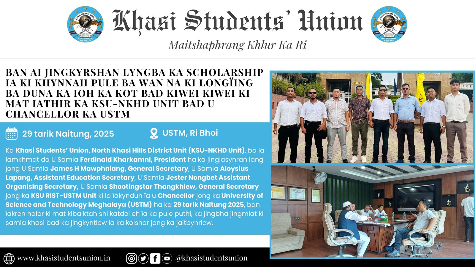
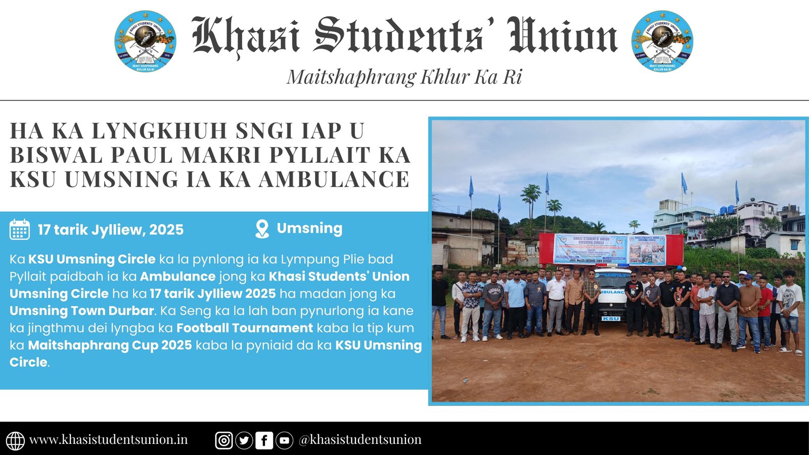
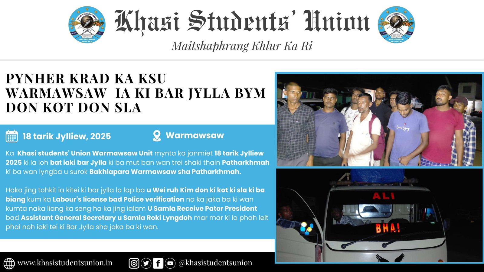
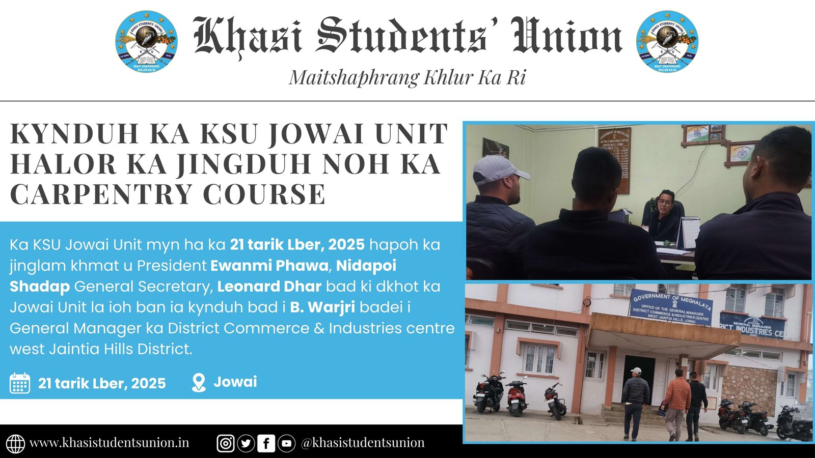
Shillong: FROM DISTRICT HEADQUARTERS TO STATE CAPITAL
- L. Gilbert Shullai
Once upon a time there was a small village in the "Land of Ki Hynfiewtrep" (RI HYNNIEWTREP) known as "Laban" and this small village has grown up to be a big town known as "Shillong". Ri HYNNIEWTREP or East Meghalaya is neither a flat land nor a semi-desert area. The frontier area, far from the 'madding crowd' in the far west is known as "Lyngngam". The northern slope land is known as "Bhoi" and the southern steepland as "War". In between the northern slope land and the southern steep land there is a tableland. The eastern portion of the tableland is known as "Pnar" to the people of the "War" area of Jaintia State (or "War Jaintia"). The middle and the western portion of the tableland is known as "Phlang" to the people of "War" area of Shella State (or "War Shella"). This "Phlang" area is also known as "Khynriam" to the people of the "Pnar" area, and on the other hand the "Pnar" area is known as "Santiang" (or "Synteng") to the people of the "Khynriam" area. Names, whether Endoethnonym or Exoethnonym, might have confused or created confusion.
Different names, whether Endoethnonym or Exoethnonym, e.g., Khasi, Jaintia, Synteng, Pnar, War, Bhoi, Lyngngam were shown in the same serial No.6 (six) of Part XI - Meghalaya of the Schedule to the Constitution (Scheduled Tribes) Order, 1950 and who knows the authority concerned, consciously or unconsciously, may feel like including more and more names bearing the names of "Regions", c.g. Khynriam or Phlang, and also more and more names of "States", e.g., Nongstoiñ, Maram, Shella, Khyrim, Mylliem, Mawlang, Sohra, etc. And who knows good sense may prevail to have only one cover term or name viz. "HYNNIEWTREP".
After the Burmese were defeated and a Treaty was concluded on the 24th February 1826 known as the Treaty of Yandaboo, the British (East India Company) along with their "Divide and Rule Policy" began to extend their political influence to the land of "Ki Hynniewtrep" known to the people of Sylhet District (now in Bangladesh) as "Khasia Pahar" or "Khasi Pahar". The expression "Khasia" or "Khasi" might have come from the word "Khas" meaning "Private, exclusive land of the owner" (Ref. K.J. Aiyer's Manual Law Terms and Phrases: page 303. 4th Edition: 1958 Publication). The Land of "Ki Hynniewtrep" or "Ka Bri ki Hynniewtrep comprises of many "States" bearing different names collectively known as "Khasia Pahar" or "RI HYNNIEWTREP".
It may be mentioned here that one of the prominent states in "Khasia Pahar" namely, Jaintia State (locally known as "Hima Sutnga") had already concluded a Treaty with the British on the 10th March 1824 when U Ram Sing was the Syiem. In 1826 (30th Nov 1826) another State namely, Nongkhlaw State (locally known as "Hima Khadsawphra") also concluded a Treaty with the British when U Tirot Sing was the Syiem. In 1829 (4th April 1829) there was an uprising leading to a war which may be known as Anglo-Nongkhlaw War. U Tirot Sing was arrested and was exiled to Dhaka. Cherra State, Rambrai State, Mawsynram State, Shella State, Myriaw State and other states had also concluded Treaties with the British East India Company.
In the year 1835 East Meghalaya, i.e., Land of "Ki Hynniewtrep" was constituted into a political agency of the British East India Company known as the Cossayah Hills Political Agency with its Headquarters at Sohra (Cherrapunjee) and located in an area known as "Saitsohpen". The area mentioned above, i.e., Saitsohpen was ceded by the Sohra State (Cherra State) to the British East India Company vide an Agreement executed in 1829 read with another Agreement executed in 1830: Ref. Aitchison's Collection of Treaties Vol.XII pp. 126-127 and p. 132. The District Headquarters was shifted from Sohra (Cherrapunjee) to Shillong in 1866: Ref: Rai Bahadur D. Ropmay's article in Ka Jingsdang ka Niam Khristan published in KA CENTENARY HISTORY KA BALANG PRESBY TERIAN (1940 Publication p. 19.)
A plot of land in Shillong which had already been ceded by the Mylliem State to the British Govern ment in 1863 may be known as "Rowlatnagar". The suggestion to shift the District Headquarters from Sohra (Cherrapunjee) to Shillong was first mooted by Major E. A. Rowlatt (the then Deputy Commis sioner, Cossayah and Jynteah Hills District) in September 1860, and it was approved by the Lieutenant Governor of Bengal, Fort William, Calcutta (Sir John Peter Grant) on 29th October, 1861 as it appears from p.98 of the book - British Administration In Meghalaya - by Dr. David R. Syiemlich of History Department, North-Eastern Hill University, Shillong.
Captain Lister was the first Political Agent in charge of the Cossayah Hills Political Agency who took charge on the 11th February, 1835. After the 15th March, 1835, i.e. after the annexation of Jaintia State which was one of the biggest Khasi States (Ref: Aitchison's Collection of Treaties, Vol. I, Part-II) the Hills portion of the said Jaintia State (previously known as Sutnga State) remained under the Cossayah Hills Political Agency but the Plains portion was tagged to the Sylhet District (now in Bangladesh).
When the Jaintia State (previously known as Sutnga State) a full fledged "British Area", the Cossayah Hills Political Agency was abolished, and a new administrative set up falling within the said Agency came into existence known as "Cossayah and Jynteah Hills District" with a Principal Assistant Commissioner as the Head of the District Administration. The first Principal Assistant Commissioner was C. K. Hudson who took charge on the 10th April, 1854. Afterwards, the designation was changed to Deputy Commissioner. Major E. A. Rowlatt, the last Principal Assistant Commissioner became the first Deputy Commissioner, Cossayah and Jynteah Hills District (Khasi and Jaintia Hills District).
In 1863, there was a negotiation with the Syiem of Mylliem State (U Mile Sing) to have a big chunk of land in Shillong. Thus, an agreement was executed, and that big chunk of land in Shillong became "British Area" and which may be known as Rowlatnagar. The Agreement of 1863 may be seen in Aitchinson's Collection of Treaties: Vol.I, pp.247-250 (also may be seen in Appendix "A' of Ki Hima Khasi by L. G. Shullai.) Construction of office buildings started in 1864 and in 1866 the District head quarters was shifted from Sohra (Cherrapunjee) to Shillong.
The above mentioned Shillong British Area which may be known as Rowlatnagar may be subdivided into three sectors, namely,
1. Lower Rowlatnagar: Lower Rowlatnagar is that part of Rowlatnagar falling within the "municipal jurisdiction" of the Shillong Municipal Board.
N.B.: There is a Mylliem State portion falling within the "Municipal jurisdiction" of the Shillong Mu nicipal Board and this Mylliem State portion is known as "Shillong (Administered Area) Municipality". (ref. Government of India Notification No.44-1 dated New Delhi the 16th January, 1934, read with Notification No.253-IB dated Simla the 7th August, 1941). Notification No.253-IB dated the 7th Au gust, 1941 relates to the inclusion of "Kench's Trace and Rilbong" in the Shillong (Administered Area) Municipality.
2. Middle Rowlatnagar: Middle Rowlatnagar is that part of Rowlatnagar falling within the Shillong Cantonment.
3. Upper Rowlatnagar: Upper Rowlatnagar is that part of Rowlatnagar falling within the jurisdiction of the Upper Shillong protected Forest. N. B.: Many plots of land in Upper Rowlatnagar have, from time to time, been allotted to Government Departments, e.g. Government Experimental Farm; to private institutions, e.g., Mahadev Khola Temple; and other private persons.
Sohra or Cherrapunjee, the rainiest place in the world, is about 33 miles and Shillong peak (about 6445 feet above sea level) is about 7 miles south of Shillong. On the other side, Sohpetbneng Peak is about 12 miles north of Shillong near the Umroi Airport, SOHPETBNENG is closely connected with the mythology of the people of "Ri Hynniewtrep". Mythology is the starting zone of history of the people of RI HYNNIEWTREP. The expression "Hynfiewtrep" reminds us of the Ethnocentric Perception and the days of Mythology where in between Heaven above and Earth below there was a "Golden Bridge". Shillong, because of its topography and climate similar to those of Scotland, is known as the "Scot land of the East" and the 18-hole Gold course of Shillong is one of the best in Asia. Shillong is surrounded by peaks and waterfalls, and so goes the song -
Shillong is a beautiful town,
Built on sacred ground;
Peaks and waterfalls all round, Shillong is a beautiful town.
Upto to the end of 1873, Assam remained as one of the Divisions of "Bengal Province". It became a separate Chief Commissioner's Province with effect from the 6th February, 1874, vide Government of India Proclamation No.379 dated the 6th February 1874 and No.380 dated the 6th February 1874 published in the Gasette of India, Part - I, the 7th February, 1874: p.53. Col. R. H. Keatinge was the first Chief Commissioner of Assam.
For a period from the 16th October, 1905 to the 31st March, 1912 Shillong ceased to be the capital of Assam, as Assam was included in the new Province known as "Eastern Bengal & Assam" with Dhaka as its capital. But after the reunification of Bengal, Assam became once again a Chief Commissioner's Province with Shillong as its capital. It may be mentioned here that Assam became Governor's Province from 1921 in accordance with the provisions contained in the Government of India Act, 1919, and Sir Nicholas Dodd Beatson Bell was the first Governor of Assam.
East Meghalaya comprises of "British Areas" and "Khasi States". "British Areas" of East Meghalaya (Land of "Ki Hynniewtrep") already became part of the Dominion of India with effect from the 15th August, 1947 (Independence Day), but the "Khasi States" fall within the political boundary of the Do minion of India after signing the Instrument of Accession (including the ANNEXED AGREEMENT) by the Heads of the Khasi States (on different dates) on one hand and the Governor General of India (C. Rajagopalachari) on the 17th August, 1948 on the other. As the "Khasi States" did not sign another Instrument namely, Instrument of Merger, therefore, it was necessary to describe in the First schedule to the Constitution of India relating to, and connected with, the territories of Assam, that Assam comprises also the territories which immediately before the commencement of the Constitution were comprised in the Khasi States. The description does not necessarily abrogate the Annexed Agreement which is part and parcel of the Instrument of Accession.
When we talk about the Constitution of India, we cannot but remember persons like Dr. B. R. Ambedkar, Sardar Patel and others. Dr. Rajendra Prasad was the President of the Constituent Assembly. Dr. B. R. Ambedkar was the Chairman of the Drafting Committee. Sardar Patel was one of the members of the constituent Assembly, and he was also the Chairman of the Advisory Committee constituted in pursuance of Paragraph 20 (twenty) of the Cabinet Mission Statement of the 16th May, 1946. Sardar Patel came to Shillong in January 1948 the leaders of the Federation of Khasi States.
On the 2nd January, 1948, there was a public meeting at the Lady Hydari Park, and in course of his speech, Sardar Patel said:
"Yours is a land for Gods to live in. Its air, its natural scenery, its pure atmosphere, its sweet water, would attract even gods if your hearts were pure".
Meghalaya was created with effect from the 21st January, 1972 in accordance with the provisions contained in the North-Eastern Areas (Reorganisation) Act, 1971. Shillong became a de facto capital with effect from that date Meghalaya is divided into two divisions (West Meghalaya and East Meghalaya) under two commissioners with their respective Headquarters at Tura and Shillong. West Meghalaya comprises of three administrative districts known as West Garo Hills District, East Garo Hills District and South Garo Hills District with headquarters at Tura, Williamnagar and Baghmara respectively. East Meghalaya comprises of four administrative districts known as East Khasi Hills District, Jaintia Hills District, West Khasi Hills District and Ri Bhoi District with Headquarters at Shillong, Jowai, Nongstoin and Nongpoh respectively.
Upto the 25th January, 1974 Shillong remained the capital of Assam, but with effect from the 26th January, 1974, Dispur was declared the capital of Assam, vide the following Notification No. GAG. 7/74/1dated Dispur, the 26th January, 1974 published in the Assam Gazette, Extraordinary No. 10. Dispur, Saturday, January 26, 1974 issued under the signature of D. Das, Chief Secretary to the Government of Assam:
"Consequent upon formation of the State of Meghalaya under Section 5 of the North Eastern Areas (Reorganisation) Act, 1971 (Act No. 81 of 1971) read with Government of India's Notification No. GSR. 18(E) dated the 6th January, 1972, the Governor of Assam is pleased to transfer the Headquarters of the State Government of Assam from Shillong in Meghalaya temporarily to Dispur in the Kamrup District of Assam with effect from the 26th day of January, 1974. The Governor of Assam is further pleased to declare test Dispur in the District of Kamrup shall henceforth be the temporary capital of the State of Assam".
(Bah Gilbert writes extensively on Khasi culture and history, and the Shillong Records Collection Centre, historical treasure trove, was his brainchild. Writer of many books, he was associated with the KHADC as its CEM in 1974.)
Ba la sot na ka souvenir jong ka KSU ba la pynmih ha u snem 1998 kum shi bynta ban rakhe ia ka jingdap 25 snem jong ka seng.
Tags :


0 Comment(s)